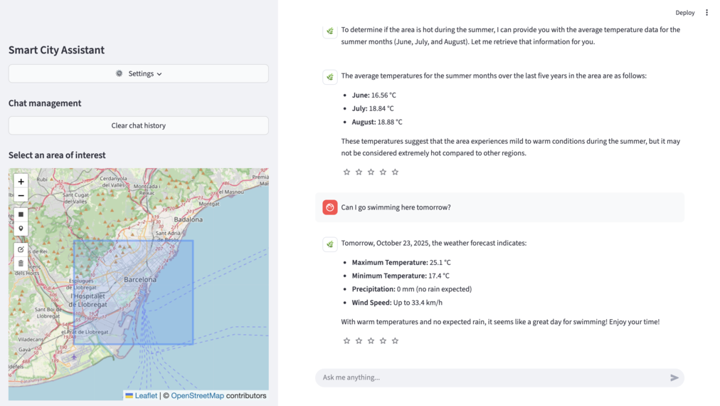
The Faculty of Information Technology of the Czech Technical University in Prague (FIT CTU) will present a special intelligent chatbot connected to map data at the Smart City Expo World Congress 2025 in Barcelona (November 4–6, 2025) — the world’s largest event focused on smart city development. The chatbot leverages advanced geospatial artificial intelligence (GEO AI) models for analysis and long-term predictions in specific locations, unlocking new possibilities for the sustainable development of cities and regions.
The chatbot was developed by the Data Science Laboratory team at FIT CTU. Its applications have a direct impact across many areas — from urban planning, transportation, and crisis management to public health, agriculture, forestry, and environmental protection. The chatbot can process large amounts of data from various sources, such as databases from the Czech Statistical Office, Eurostat, the Land Registry, or transportation systems. The result is a precise, location-specific answer.
For example, it can determine local weather conditions, assess whether planting a certain crop is worthwhile, or evaluate the suitability of a site for building a hotel. In doing so, it considers the availability of shops, traffic conditions, proximity to water bodies, and other factors influencing the attractiveness of the location. This enables the chatbot to answer highly specific questions that ordinary chatbots cannot process accurately.
“This project shows that artificial intelligence can be a truly practical tool for the sustainable development of cities and landscapes,” says Mgr. Alexander Kovalenko, Ph.D., co-author of the chatbot and member of the Data Science Laboratory at FIT CTU. “Our goal wasn’t just to create technology, but to offer a real solution that connects data, space, and decision-making in real time. We’re looking forward to seeing the interest our chatbot will spark among city representatives, experts, and companies from around the world — it’s exactly this exchange of ideas that drives innovation forward.”
The chatbot is transforming planning and decision-making in multiple areas:
-
Road maintenance – identifies which roads require winter treatment and where it’s unnecessary due to a lack of snow or frost forecasts.
-
Mobility analysis – uncovers migration trends within regions using anonymized data.
-
Rail transport – helps prevent track expansion risks during heatwaves.
-
Disaster evacuation simulations – models evacuation routes, bottlenecks, and timing.
-
Real-time support for emergency services – integrates data on unit positions, traffic, and weather.
-
Land investment potential assessment – combines data on transport, service accessibility, and long-term trends.
-
Property depreciation risk analysis – monitors impacts of noise, pollution, and industrial proximity.
-
Land value growth prediction – based on demographic and infrastructure developments.
-
Tourism attractiveness analysis – evaluates accessibility, climate, service density, and environmental factors.
-
Visitor traffic prediction – helps cities and businesses plan capacity and marketing based on expected demand.
-
Agriculture – provides highly accurate local weather forecasts (up to 2°C more precise) using high-resolution satellite images and local meteorological data; supports harvest, irrigation, and planting planning.
-
Forestry and nature conservation – predicts drought and monitors landscape changes.
-
Crisis management – identifies flood-, fire-, and hazard-prone areas in advance.
-
Public health and urban planning – supports spatial and predictive decision-making.
-
Urban heat island monitoring – assesses temperature differences across city zones and proposes green solutions.
-
Soil erosion prediction – analyzes topography, vegetation, and rainfall.
-
Wildfire risk prediction – tracks vegetation, temperature, humidity, and wind.
-
Drought risk identification – combines rainfall, evaporation, and soil moisture data for early warnings.
The Smart City Expo World Congress is the largest and most influential global event dedicated to sustainable urban development and innovation. It annually welcomes over 25,000 participants from more than 850 cities, with 1,100 exhibitors and 600 speakers. FIT CTU’s participation reaffirms the position of Czech science and technology among the world leaders in smart cities and artificial intelligence.


